About this Website!
Made with love for the space community by Kyle Marquis, starting in June 2022. This idea started from an open-ended final project in his Engineering Data Analysis class, taken as part of his Aerospace Engineering Master's Degree program at the University of Colorado Boulder.
Why?
Initally, seeing that there was a lack of information regarding temperature data over the range of latitudes being examined for possible future bases and landing sites, this project took on the task to provide engineers and planners knowledge on what to expect once on the surface of Mars. However, after release, it was found that JMARS KRC Layer can provide actual predictive capability for maximum and minimum temperatures, much better than this site can help with due to limited temporal data. Consequently, the purpose of this site shifts to be a resource to show qualitative trends in temperature versus latitudes and longitudes. Why is this and JMARS temperature data important?
Finding cheap and accessible polymer films which maintain their ductility (deformation before breaking) below temperatures of -100 C (temperatures typically seen on Mars) can be challenging. Polymer films are useful in creating lightweight expandable habitats, such as the BEAM module on the International Space Station, which used pressure bladders from Thin Red Line Aerospace. More recent expandable habitat designs include Sierra Nevada's LIFE habitat with urethane bladders and Vectran fabic weave, or Lockheed Martin's Starlab inflatable habitat concept. As a result of the limited operating temperature range on these film materials, prospective designers or engineers may want to weigh the pros and cons of selecting locations that are equatorial enough to maintain reasonable temperatures, while still being North enough to find sufficient stores of fresh water-ice. If heating is unavailable for an inflated habitat you wouldn't want it to become brittle like glass and shatter.
Predicting power usage will depend on heating losses in future Mars habitats as well. Modeling radiative, convective, and conductive heat losses will require knowledge of the surrounding environment. Furthermore, chemical reactions, such as the Sabatier process to create methane from carbon dioxide and hydrogen, are sensitive to reaction temperature. Accordingly, having an understanding of the enviroment's ambient temperature will aid in the development of future industrial plants to support colonies and return journeys from Mars.
Designing space suits for Martian astronauts will be no easy task. One of the most difficult challenges is actually cooling the astronauts. Cooling using water sublimation (such as on traditional spacesuits) is more challenging due to a lack of strong vacuum, and would require significant disposable mass of water for crewed missions. This is noted in Jeremy P. Stroming and Dava J. Newman's Critical Review of Thermal Management Technologies for Portable Life Support Systems (pdf). Understanding external ambient temperatures will be critical to the selection and design of the technology to enable human exploration on the red planet.
A tool which allows people to find temperature data for regions they are interested in could inform crucial engineering trade-off decisions affecting new mission planning. It's expected that the time-varying JMARS temperature predictions match the specific time-of-day data from the MRO spacecraft displayed in this website, but this will require future validation.
Dataset
Data is gathered from the Mars Reconnaissance Orbiter (MRO) volumes within the PDS Atmospheres Data Set Catalog, using the Mars Climate Sounder instrument. Specifically, MROM_2XXX data files are analyzed. Periodically, new chunks of processed MROM data is made available and I will add it to this site's database to be presented.
This is data that has been processed from the raw files, and calibrated to be accurate for those using it. As that website states, it's NASA Level 2, CODMAC Level 5 which means "Geophysical parameters, generally derived from NASA Level 1 data, and located in space and time commensurate with instrument location, pointing, and sampling."
Units and details of reading the dataset was found in the document: Mars Reconnaissance Orbiter, "Mars Climate Sounder Derived Data Record (DDR) Software Interface Specification", Version 1.2 October 25, 2012, Ronald Joyner and Elias Sayfi, JPL D-46674. Retrieved from https://ode.rsl.wustl.edu/moon/pagehelp/Content/Missions_Instruments/Mars%20Reconnaissance%20Orbiter/MCS/MCS.htm
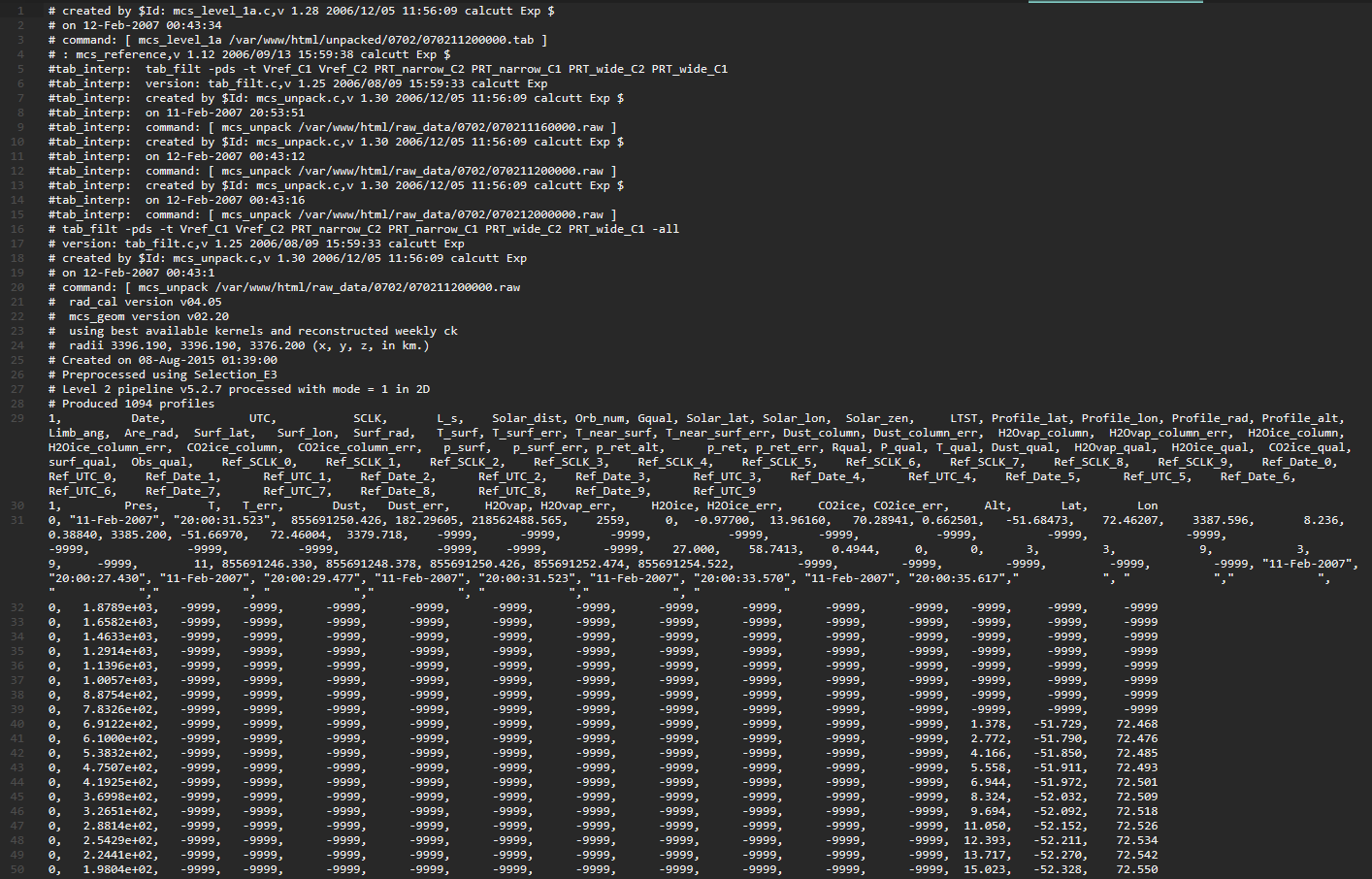
and then imagine these lines repeated tens of thousands of times per file, with multiple files per day, for almost every day
Information about the Mars Climate Sounder instrument aboard the MRO spacecraft can be found here, with a simplified explanation on NASA's site.
References
The image of Mars can be found in the public domain from astrogeology.usgs.gov
Mars Climate Sounder paper including instruments, and selected orbit for maintaining a ~3pm equator crossing time with full latitudinal coverage. https://agupubs.onlinelibrary.wiley.com/doi/full/10.1029/2006JE002790
JMARS Links
JMARS with KRC demonstration for calculating temperature over the day and night https://jmars.mars.asu.edu/krcLayer
JMARS homepage https://jmars.asu.edu/
KRC program page http://krc.mars.asu.edu/index.php?title=Main_Page
MARSTHERM is a similar tool for calculating diurnal temperatures https://marstherm.psi.edu/
Resources on Solar Time
See definition of apparent true solar time https://gml.noaa.gov/ozwv/dobson/papers/report6/appi.html#:~:text=The%20solar%20day%20therefore%20begins,%2B%2012h%20%3D%2015h
Further reading on solar time https://www.sciencedirect.com/topics/engineering/apparent-solar-time
Hour angle definition https://en.wikipedia.org/wiki/Hour_angle
Resources on Latitude and Longitude
Reference for degrees of latitude equaling ~59 km https://mars.nasa.gov/mgs/sci/mola/mar10-2000/internal_paper.html
Reference for longitude length between degrees changing based on latitude https://www.thoughtco.com/degree-of-latitude-and-longitude-distance-4070616
Resources on Water Ice Availability on Mars
Large sheets of pure ice have been found a few meters below the surface in Martian mid-upper latitudes. Wikipedia: Water on Mars is a great first step to find source documentation and keep up to date.
For example, Water ice cliffs on Mars https://www.science.org/doi/10.1126/science.aao1619
Reach out with suggestions or comments!
Please add "MarsTemps" in subject line


